

Elkaddict
-
Content Count
1,572 -
Joined
-
Last visited
-
Days Won
4
Everything posted by Elkaddict
-
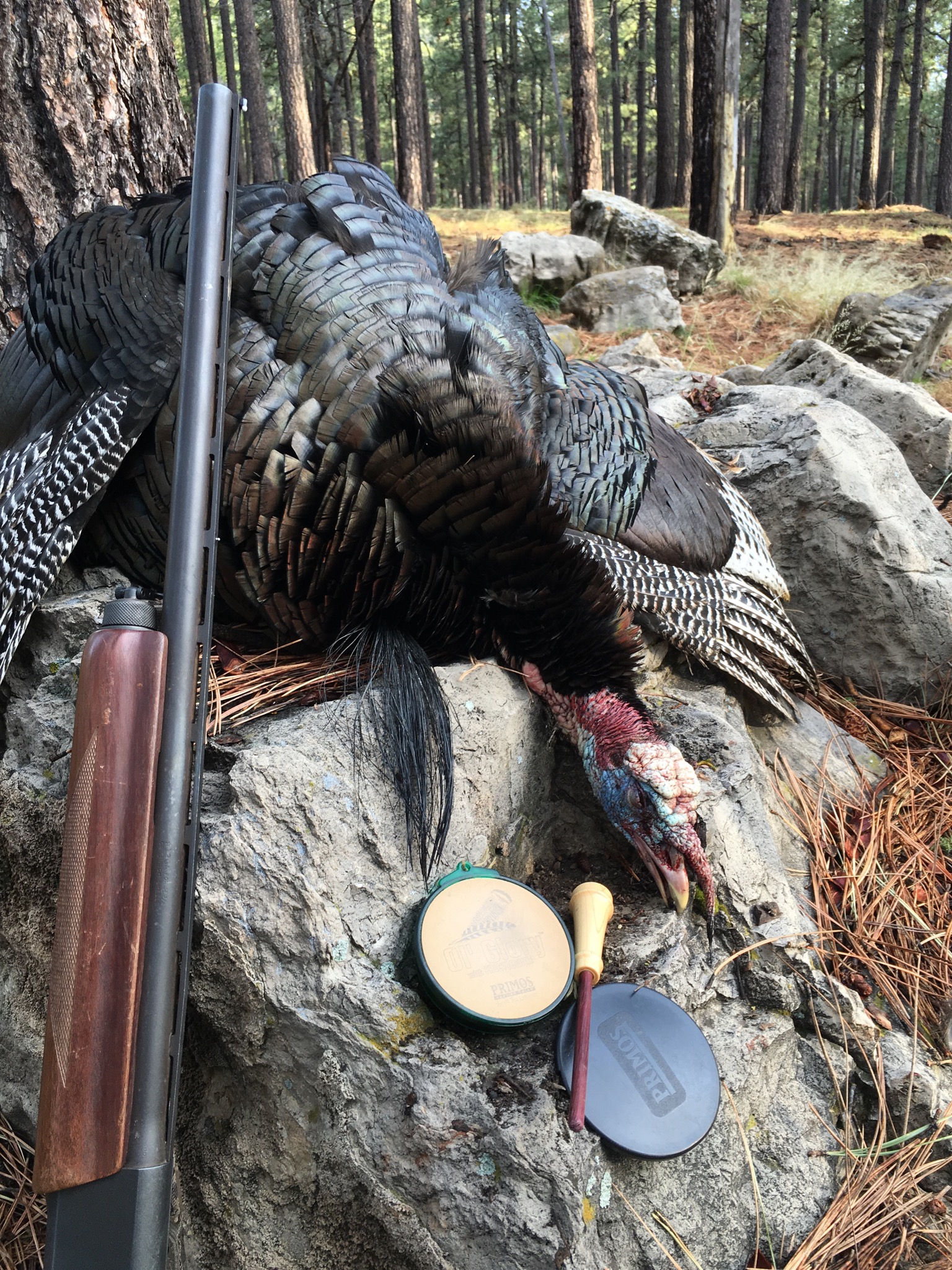
I'll tell you how it went this morning, had 2 toms on their roost going crazy gobblin. I get set up kind of close but not too close, when I hear the hens talking a little I let out some purrs on the foxpro. The toms go wild, gobbling constantly. Then just like every other day they get off the roost and walk away. Where too I do not know! What am I doing wrong???
-
I'm having the same luck as Ron, hearing birds every morning (except 1) but not getting them in. No sounds at all in the evening. Heading out now.
-
Get it you won't regret it!
-
Coconino Forest has a map for downloading to your gps to show roads you can be on, camping areas,elk retrieval areas, etc. http://www.fs.usda.gov/detail/coconino/landmanagement/projects/?cid=stelprdb5356224 Not sure I want to do this, but figured I do want to be legal so might as well. I loaded the application to my desktop and tried to load to my garmin 60c, it recognizes the gps unit but can't seem to get it installed. So I went to my desktop and loaded the application there, as soon as I plugged in my gps the screen turned blue and I spent the next 2 hours getting that computer back to normal. Has anyone else tried this and what were the results. WARNING- I told you what happened to me, not saying that was the only problem but that was all I was doing. SO............
-
Great looking birds! Congrats, too bad the WMAT is so pricey!
-
Anti gun commercial
Elkaddict replied to Pine Donkey's topic in Political Discussions related to hunting
Neat video! -
A friend told me this happened to him a couple of years back, don't know what he did to cure it. Google "dodge death wobble" and you will see lots of people talking about it.
-
I finally loaded the map to Garmins Basecamp. It's worse than the one they offer online and have printed for us to use. All I see is a blue background with elk retrieval and no elk retrieval and some roads. I would be lost most of the time trying to use it. Horrible!!
-
Credit card Issue in draw equals no Elk tag!
Elkaddict replied to mulie hunter's topic in Elk Hunting
This happened to a friend and his son a few years ago. Outcome---2 unit 10 early bull tags...Copngrats! -
What subdivision? I'm in Clear Creek Pines unit 8, I've heard of a bunch of breakins through the winter. TV's, quads,tools,guns,you name it have been stolen. Even heard of sheds being taken. The thieves MO sounds like someone with local knowledge of the roads,etc. If anyone has any info on these guys we need to get them caught! They have to be selling this stuff to someone!
-
Congrats!
-
Ann Barnhardt --one tough women
Elkaddict replied to Pine Donkey's topic in Political Discussions related to hunting
If you haven't seen it, here is the video that POed the muslims. -
The bowflex is nice, you can hang a lot more clothes on it than the exercyle!
-
Not exactly at least in the Coconino. Hear is a quote from "Record of Decision" dated September 28, 2012, "Motor vehicle use for the purpose of dispersed camping is allowed within 300 feet along both sides of 581 miles of designated road and along one side of 32 miles of designated road. These motorized dispersed camping corridors are shown in the Record of Decision Map Packet. The area open to dispersed camping totals an estimated 43,313 acres. Where dispersed camping corridors are not designated, Forest visitors may park up to 30 feet off the road edge to camp or to pursue other activities. The reason this decision allows parking up to 30-feet from the side of the road in areas without dispersed camping corridors is (a) to be consistent with adjacent national forests, ( to allow ample room for parking for all vehicle types, and © to limit motor vehicle impacts adjacent to the road corridor in undesignated areas." On the Kaibab in the Williams and Tusayan Ranger Districts it looks like all dispersed camping must be within 30 feet of an "designated open road" and it does not look to me like the North Kaibab Ranger District has finalized their plan unless I misread. Lee From this I take it ,along any open road ,as long as your vehicle is parked no more than 30 ft from the road edge, your camp can be where you want it. Any designated road. You need to look at the map to see the designated camping roads.(at least thats how I read it, you have me confused now!)
-
5A for me, can't wait to hear some gobblers!
-
If you're not one of the members of CWT, Azhunter or ruttinhard, you wouldn't have a clue as to what these regulations are all about. I'd bet less than 10% of the people camping this summer are aware of this ruling. Not going to be pretty!
-
Glad to hear that.
-
Yep, shes hooked!!
-
I'm with you on this, they spent all last summer numbering roads and putting signs on waterholes and ridges, they should be able to put signs on open and closed roads this summer. I've seen signs on old logging roads on the rim that say road closed and I think for the most part people abide by that. Memorial weekend will be the first big test, interesting to see how that works out. I think going off road to retrieve an elk (and not to chase them or look for drops)wouldn't hurt the land, but don't know how to get that turned around. Bottom line is there are too many roads and too many people in the forest abusing the current travel laws. So far I am having a hard time figuring out the map. No waterholes, canyons,etc named on the map, hard to figure where you are. Going to be an interesting summer.
-
Matt, I agree with you. As you can see by my previous post my biggest problem with the rule is not knowing what road is open or closed. I am going to assume all the little roads we have used for years are closed, but what about some of the major roads that have metal swing gates and asphalt entrances off Hwy.87 that I don't see on the new map? They better do something to inform the campers that only come up a couple of times a year, they aren't on this or any other outdoor forum, how are they going to know they can't camp in the spot they have been going to for the last 10 years? I'm going to have a hard time not being able to go off road to retrieve an elk, but I'll get over that. I just have a hard time trying to figure out this lousey map they came up with!
-
The map sucks! There aren't any topo features to figure out where you are. IE: jacks canyon, east clear creek, water holes etc. If I see a road and it is heading to clear creek can I assume it goes all the way to the edge like it does now? Or more simply put if the road is on the map can you take it to the end or can they close it someplace before where it goes now.(understand what i am trying to say?) To be more specific there is a road through Mogollon Ranch,319, that on this map appears to stop a couple of hundred yards north of the subdivision then picks up again at the south edge of private property. I am going to buy a map next week at the ranger station to see if it is clearer than the one online.
-
Good start!
-
Great pics, lots of horn!!
-
2012 California Turkey Hunt Pics II
Elkaddict replied to Jay Scott's topic in Jay Scott Outdoors/Colburn and Scott Outfitters
Nice birds and beautiful country! Don't understand why someone would give you a negative on the post...Weird.. -
Weird enough!! Good pictures!